Press Release
Contact Information:
Rylan Gervase, Director of Legislative & External Affairs
415-961-9088
rylan.gervase@bcdc.ca.gov
August 7, 2025
FOR IMMEDIATE RELEASE
Commission votes to explore high occupancy vehicle lane on the Richmond-San Rafael Bridge and to encourage public access to the bridge.
Commission authorizes a breakdown lane during peak commute hours and a multi-use path for bikes and pedestrians during all other times.
San Francisco, California — Today, the San Francisco Bay Conservation and Development Commission (BCDC) voted to approve a request from California Department of Transportation (Caltrans) and the Metropolitan Transportation Commission (MTC) to test new transportation options between the North and East Bay and improve public access to the Richmond-San Rafael Bridge.
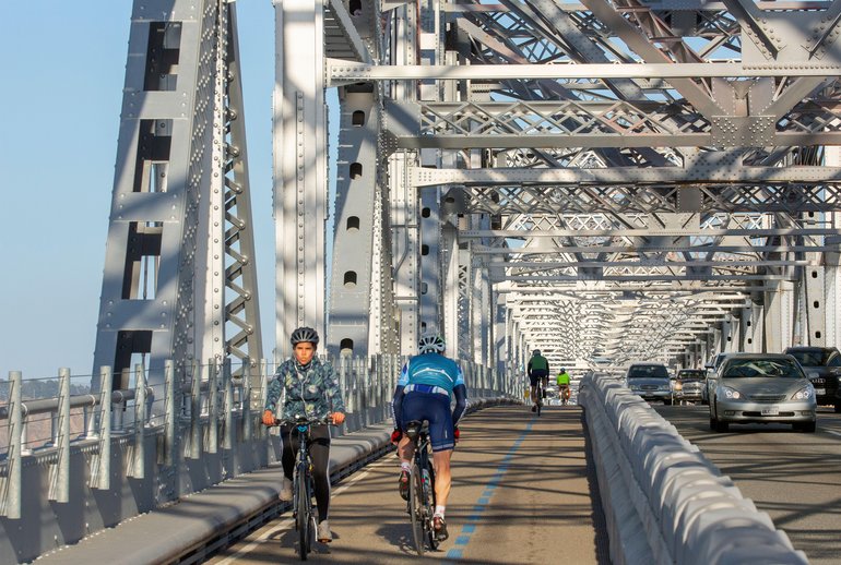
Cyclists and motorists share the road on the upper deck of the Richmond-San Rafael Bridge. Photo courtesy of Alamy.
The change in operations will allow Caltrans and MTC to test and study elements of the Westbound Improvement Project, including the feasibility of a part-time high-occupancy vehicle lane for mass transit and carpools and a part-time multi-use path for cyclists and pedestrians on the upper deck. A preliminary study found that the Westbound Improvement Project could save commuters traveling to the North Bay 10 to 19 minutes per trip. The transportation agencies will use the next three years to study the impact on safety, bridge traffic, and nearby vulnerable communities.
The commission approved the use of the westbound shoulder on the upper deck as a breakdown lane to test the Westbound Improvement Project on weekdays from 11 p.m. on Sundays to 2 p.m. on Thursdays. During these hours, the breakdown lane will be open to emergency vehicles and allow disabled vehicles to pull over without obstructing traffic.
On weekends, from 2 p.m. on Thursdays to 11 p.m. on Sundays, the shoulder will continue to serve as a multi-use path for pedestrians and cyclists. The path will be protected by a moveable barrier that separates it from the vehicle lanes. A free shuttle will be available between 6am and 8pm on days when the path is closed to transport pedestrians and cyclists across the bridge. The path will additionally be open around certain holidays which will be posted on the trail and on MTC’s website.
Caltrans and MTC will implement these operational changes to the Richmond-San Rafael Bridge starting this fall. Caltrans and MTC will report to the commission on the impact of the changes following the conclusion of a three-year study period in 2028. The transportation agencies will then propose a long-term plan for the upper deck for the commission’s consideration.
The commission conditioned its approval of modified operations at the Richmond San-Rafael Bridge on funding for active transportation projects that improve public access to the bridge. Caltrans and Bay Area Toll Authority (BATA) staff will recommend allocating $10 million in Regional Measure 3 funds to support two key local projects:
- Richmond Wellness Trail Extension: A new 1.1-mile bike path segment to close the gap between Cutting Boulevard and the Richmond Ferry Terminal, completing the 4-mile Richmond Wellness Trail.
- Neighborhood Complete Streets: Improvements to a 1.7-mile segment of Harbour Way from I-580 to Downtown Richmond to improve safety and accessibility including lane reductions, bike lane installation, and pedestrian lighting.
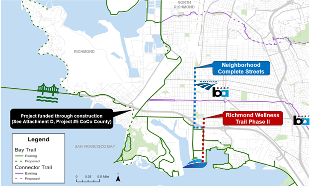
Map courtesy of the Metropolitan Transportation Commission.
The commission also approved the permanent daily use of the shoulder on the lower deck and eastbound approach as a vehicle travel lane during afternoon and evening peak hours, from 2pm to 7pm. Data provided by Caltrans and MTC shows that this part-time lane saves commuters traveling to the East Bay an average of up to 17 minutes per trip during peak hours.
“Today’s vote allows the region to make an informed decision on the long-term future of how the public will use the Richmond-San Rafael Bridge,” said BCDC Chair R. Zachary Wasserman. “These changes will help improve public access to the bridge and get travelers across as quickly as possible.”
—BCDC Chair R. Zachary Wasserman
“BATA’s commitment to direct millions to improve access to active transportation in Richmond will ensure that vital bike and pedestrian projects are completed, which also improves the health of the community,” said John Gioia, Contra Costa County supervisor and BCDC Commissioner. “We need to improve the connections to the bridge if we want to get people out of their cars and using alternative transportation.”
—BCDC Commissioner John Gioia
###
About the Richmond-San Rafael Bridge: Located on Interstate 580 between Contra Costa and Marin counties, the Richmond-San Rafael Bridge is a vital link between the North and East Bay. More than 13 million toll-paid vehicles crossed the bridge in 2024. Since 2019, Caltrans and MTC have tested a multi-use pathway on the upper deck and westbound approach. The path is open 24 hours a day, seven days a week. Since the path opened, pedestrians have made almost 60,000 trips and cyclists have made over 400,000 trips across the bridge. Caltrans and MTC have also tested a part-time third vehicle travel lane on lower deck and eastbound approach of the bridge to ease congestion during the afternoon commute.
About BCDC: Established in 1965 to plan for and manage the unregulated filling of San Francisco Bay, BCDC is the primary State agency responsible for improving public access to the Bay and its shoreline.